As a leading authority in the integration of cutting-edge technologies for the real estate and urban planning sectors, we are proud to present our innovative solutions in 3D underground mapping and ground-penetrating radar (GPR) utility surveys. These advanced techniques are transforming the way urban planners, developers, and real estate professionals approach infrastructure projects, ensuring that every venture is backed by precise data and meticulous planning.

The Future of Urban Planning and Real Estate Development
In the modern world, the complexity of urban environments requires a sophisticated approach to planning and development. Urban planners and real estate developers face the challenge of balancing growth with sustainability, ensuring that new projects are safe, efficient, and harmonious with existing infrastructure. This is where our expertise in 3D underground mapping and GPR utility surveys becomes invaluable.
Understanding 3D Underground Mapping
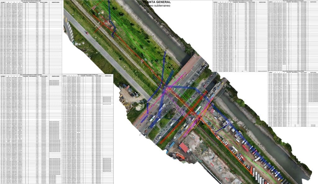
3D underground mapping is a revolutionary technique that provides a detailed, three-dimensional visualization of subsurface conditions. By using state-of-the-art technology, we can create comprehensive maps that reveal the intricate network of underground utilities, geological formations, and other subsurface features.
This level of detail is crucial for urban planners and developers who need to understand the existing conditions beneath the surface to make informed decisions. With 3D underground mapping, potential conflicts with existing utilities can be identified early in the planning process, reducing costly delays and ensuring a seamless integration of new infrastructure with the existing one.
The Role of Ground-Penetrating Radar (GPR)
Ground-penetrating radar (GPR) is a non-invasive technique that uses radar pulses to image the subsurface. GPR is highly effective for identifying the location and depth of underground utilities, such as water lines, electrical conduits, and sewer systems.
By employing GPR in utility surveys, we provide our clients with precise information regarding the infrastructure beneath their development sites. This data is essential for avoiding unexpected encounters with utilities during construction, which can lead to project delays and increased costs.
Combining Technologies for Superior Results
At PCM CLOUD by Procimec Engineer, we leverage the synergy of 3D underground mapping and GPR to deliver unmatched accuracy and reliability in our utility surveys. By combining these technologies, we offer a comprehensive mapping solution that addresses the intricacies of subsurface conditions.
Our integrated approach ensures that our clients receive a detailed understanding of the underground environment, allowing for proactive planning and risk mitigation. Whether you’re developing a new residential community, commercial complex, or a mixed-use space, our services provide the foundation for confident decision-making.
Benefits of Our Services for Real Estate and Urban Planning
Enhanced Safety and Risk Management
Safety is paramount in any construction or development project. By utilizing our 3D underground mapping and GPR utility surveys, urban planners and developers can significantly enhance safety measures. Accurate mapping of existing utilities prevents accidental damages during excavation, reducing the risk of hazardous situations that could compromise worker safety and project integrity.
Cost Efficiency and Time Savings
Unexpected encounters with underground utilities can lead to costly project delays and budget overruns. Our services minimize these risks by providing a clear and accurate depiction of subsurface conditions. By identifying potential conflicts and planning accordingly, developers can avoid unnecessary expenses and keep projects on schedule.
Improved Project Planning and Design
With comprehensive data on subsurface conditions, architects and engineers can optimize their designs to align with existing infrastructure. This results in more efficient and sustainable developments, as projects are tailored to integrate seamlessly with the urban environment. Whether it’s maximizing green spaces or optimizing utility layouts, our services enable informed decision-making at every stage of development.
Environmental Sustainability
Understanding the underground environment is essential for promoting environmentally sustainable development. Our services allow planners to minimize the impact on existing ecosystems and make data-driven decisions that align with environmental regulations. By preserving natural resources and avoiding unnecessary disturbances, developers can contribute to the sustainability of urban landscapes.
Compliance with Regulations
Navigating regulatory requirements is a crucial aspect of any development project. Our comprehensive utility surveys help ensure compliance with local, state, and federal regulations. By providing accurate documentation of subsurface conditions, we support our clients in meeting regulatory standards and avoiding potential legal challenges.
Our Process: Precision at Every Step
At PCM CLOUD by Procimec Engineer, we are committed to delivering excellence in every aspect of our services. Our process begins with a consultation to understand the specific needs and goals of your project. We then employ our advanced 3D underground mapping and GPR technologies to conduct a thorough survey of the site.
Our team of experienced engineers and geospatial experts meticulously analyze the data to create detailed maps and reports. We present this information to our clients in a user-friendly format, providing actionable insights that guide the planning and development process. Throughout the project, we maintain open communication and collaboration, ensuring that our clients are informed and confident in every decision.
Partner with Us for Success in Real Estate and Urban Planning
PCM CLOUD by Procimec Engineer is your trusted partner for modern urban development. Our innovative 3D underground mapping and GPR utility surveys empower real estate professionals and urban planners with the precision and clarity needed to excel in today’s complex environments.
Contact us today to learn more about how our services can support your next real estate or urban planning project. Together, we can build the cities of the future—safe, efficient, and sustainable from the ground up.

